Tuesday, August 31, 2010


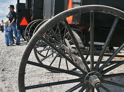
THE MT. HOPE AUCTION is bustling with its weekly activity (top) while a young Amish father and his children (below) are pictured behind their family vehicle—the horse drawn variety, one of countless others in this bucolic setting.

A DAY TRIP TO AMISH COUNTRY--

Here’s a spiffy idea for an easy day’s road-trip. Glide the family chariot to Kidron, OH and take a peek at Lehman’s Hardware and their amazingly enlarged emporium stuffed with goodies to support a relaxed and environmentally friendly life-style.

Kidron is just a chip shot east of Apple Creek between US routes 30 and 250.

Sue and I met friends Dave and Cathy Richardson there for a mid-morning tour then headed south for Mt. Hope and their weekly, Amish auction.

The road in front of Lehman’s drops south, crosses US 250 and wyes into SR 241 straight to Mt. Hope. Their auction is held every Wednesday. There you will find a delightful auction barn where livestock is sold at warp speed.

The barn area is surrounded by a flea-market of seasonal produce and enough other goodies to satisfy everyone’s urge to consume—something.

The county road on the east side of the auction facility is CR 77 and drops straight south to a stop light at US 62 where a right turn will deposit you in Berlin; the shopping Mecca smack dab in the center of the largest Amish community in the US.

From Berlin we meandered south then west on pastoral country roads through a half dozen or so rural miles of Amish countryside to the Millersburg Hotel, a charmingly restored facility from that time long past.

It’s been there since before Mr. Lincoln was president.

Their dining tavern is a great place to soothe one's aging bones as a marvelous day with good friends dissolves into one of life's nice memories.

From the front door of the hotel, point the family chariot west. You will be on SR 39, less than 40 miles from Mansfield.

_________________________
http://www.lehmans.com/
http://www.mthopeauction.com/
http://www.ohioamishcountry.com/
http://www.hotelmillersburg.com/

Monday, August 30, 2010


GYPSIE (lower left above)...


...and her best friends Dick and Jan Shafer prepare our evening’s campfire at their hide-away digs, Lake Timberlin, in southern Richland County where Sue and I recently enjoyed the shake-down cruise in our camper.

It was one of those evenings that end all too quickly in the warm fellowship of treasured friends.

Our camper is now scheduled for our three-day, four-night adventure of square dance camping over Labor Day in eastern Ohio.

After that it likely will experience a short hibernation before it rolls with us for our first-ever snowbird experience in central Florida with non-other than--

--Gypsie and her friends.

Life is good!

Saturday, August 28, 2010


Mike Cecil (above) from the Richland County Engineer’s office does some record keeping work at the site of the US Geodetic Service monument along Lexington-Ontario Road which is in close proximity to the county’s highest elevation.

AND, OUR COUNTY’S
HIGHEST ELEVATION IS--

...Well, this story began when I overheard two guys debating the location of the highest point in Richland County.

One was vehement in his assertion it was the top of Mt. Jeez near Malabar Farm. The other was arguing for the Mansfield airport’s lofty elevation.

Both were wrong.

I stayed silent in their private debate—but, could remember that site being just a chip shot southwest of Twin Lake’s Golf Course in county maps from the early 80s when I was a commissioner.

That elevation was then set at 1,505 feet above sea level.

My search for current data led me to Mike Cecil a long-time friend who serves as a project manager in the Richland County Engineer’s office.

...and I learned, using modern tools and technology of the survey trade, that site has now been measured to be in a young orchard on the west side of Lexington-Ontario Rd., just a wee bit north of the entrance to Apple Hill Orchard.

It is located there within the 1511 foot contour interval on the county’s topographical map.

There is a US Coast and Geodetic Survey monument on the east side of Lex-Ontario Road just north of the orchard’s parking area with an elevation measured at a very precise1,509.97 feet.

I found a comparison of these numbers to be both a testament to more modern GPS technology and a salute to the high accuracy of older measuring techniques.

Prior to a site visit with Mike he introduced me to Kevin Payne a deputy engineer and chief surveyor in the engineer’s office. We had a delightfully, technical discussion on how such elevations are determined these days.

My head tingled as I sought to understand phrases such as: derived deflections, or, horizontal coordinates being established by classical geodetic methods.

Kevin and Mike talked of orthometric heights and LaPlace’s Equation like ordinary folks would discuss a pizza order.

Today’s accuracy of survey-type measuring techniques is down to ¼ inch horizontally and 1/10 of a foot vertically.

In that nicely rambling discussion I also learned the lowest elevation in the county is on the south side of Base Line Rd., west of Plymouth and near the Crawford County line. It is in a creek ravine at an elevation of 940 feet above sea level.

During my visit I also had a nice chat with another old friend and engineer Jim Lichtenwalter and, in discussing county watersheds learned there is a mere 8 feet of fall along the Black Fork River from Shelby to Charles Mill Lake.

There is more fall than that in a creek that crosses the narrow dimension of my 9 acres in the hills northeast of Bellville.  No wonder that area up there is prone to flooding.  But, that is another story.

As we wrapped up work at the site of the highest elevation, Mike chuckled as he explained his red and white striped steel pole (visible in the top photo), once a fundamental tool of the survey trade, was known as a range rod used for tangent alignment—and shaking the bushes for snakes.

“These days I mostly use it like a cane; to help me get up from ground level work,” he quipped.

____________________
By the way, the elevation of Mt. Jeez is a mere 1,295 feet and the official elevation of the Mansfield airport is 1,297 feet.

The highest elevation in Ohio is 1,549 feet—just east of Bellefontaine.


The Old Timers in the photo above are a survey crew, thought to be from the early 20th century. In those days they had members assigned as the foreman, instrument men, chain men, and axe men for clearing sight lines. Today it is not inconceivable that one man with modern equipment could accomplish the same task. That’s Mike and Kevin working behind the photo in the county engineer’s office.

Thursday, August 26, 2010


A PEEK AT RICHLAND COUNTY’S
HIGHEST ELEVATION--

Above is the top of a US Coast and Geodetic Survey monument located along Lexington Ontario Road south of Noblet Road in Springfield Township. It is one of several hundred in the county and they record a precise location or elevation used by engineers, surveyors, mapmakers, etc.

Saturday, Fogeyisms will visit this monument as part of our story dealing with the highest elevation in our county. This monument was established in 1959 to identify this location, which just happens to be close to the highest elevation known. We hope you will come along and enjoy our exploration.

Wednesday, August 25, 2010


GOOD GRIEF!

The end of summer is near

We took advantage of one of the last days of summer vacation for Sue’s grand daughter Mackenna recently with a game of miniature golf at the very nice Dutch Heritage Restaurant facility on SR 97 near Bellville.

This facility is laced with running streams of water with a waterfalls splashing over the tunnel on the “fairway” of the sixth hole.

Tuesday, August 24, 2010

ONE OF LIFE’S TREASURES--

Life surprises you with a nice gift once in awhile.

Mine showed up one recent evening when eight square dancing friends accepted an invitation to be the entertainment at the annual picnic of the local Multiple Sclerosis support group.

I gave a silent prayer of thanks for my gift of good health as we assembled for a picnic-style covered dish feed in the presence of these folks; some family or friends, and some afflicted with this horrible disease—many already confined to wheelchairs.

We did our dances to a chorus of smiles from that appreciative audience.

Soon our square was half populated by MS victims as our invited dance partners, whirling to our caller’s musical chant; they with not quite polished dance moves but with more than abundant energy and rousing enthusiasm.

I was beaming inside as the magic of that moment unfolded.

Then, to my amazement, three fellows in wheel chairs accepted our invitation to dance and partnered with our ladies while our male dancers stepped behind the chairs to provide helpful propulsion.

And, away we went with the new “couples” wiggling and giggling in the real dance move of “Forward and Back”.

That quickly morphed into learning—and doing, more or less,—the Allemande Left. ...which led to the “Right and Left Grand,” a circling move where the ladies go one way and the fellows go the opposite while weaving among each other.

Even the confusion of inexperience was hilarious. The smiles were electrifying.

The crushing burden of the affliction was gone! ...at least for those shining moments.

A rowdy celebration of gentle high-fives followed the last musical note and my heart was rattled when a beaming and wheelchair confined victim, John Precup, thanked me for being his engine.

...a gift I will long treasure.

_________________________________
Our dancers:  George and Judy Osborne, Frank and Bernie Phillips, Butch and Betty Hoke, Sue Brooks and Terry Wolf.  Our caller:  Brian Fellows.

Monday, August 23, 2010

MY HYPOTHESIS—

Today’s standard of excellence is mediocrity.

Four of us stopped into Buck’s Restaurant in Lexington for dinner Saturday and were ushered to the booth in the southeast corner of the dining room.

When Sue slipped into her seat I heard a mild squawk as I shed my rain jacket and eased toward the seat beside her.

Have you ever started to sit down only to feel mild terror as your behind fell far past where you expected it to land?

I thought my chin was going to smack the table top.

After my very ungraceful arrival, I had to look up at an angle about like watching an air show to see my companion across the table.

I do not know what the problem was with that seat—but it was almost dangerous. And, the waitress’s restrained smile suggested the problem was commonly known to the staff as she quickly granted our request to be seated elsewhere.

Shame on you Bucks.

Sometimes fancied as Lexington’s most trendy joint, you should be able to afford safe furniture.

Saturday, August 21, 2010


Rosa Hatfield ascends the trail to Whipp’s Ledges in Medina County as she, husband Rich, lady friend Sue Brooks and I explored that slice of Ohio geologic history on a recent Sunday outing.


THE HINCKLEY RESERVATION--

We headed to the Hinckley Reservation that day to take a peek at their hiking facilities.

You likely know that area best as the springtime gathering spot of Turkey Vultures who make their annual return to an Ohio roost on March 15th. Up there they call the birds buzzards.

Our visit started on the Hinckley Lake Loop Trail, a 3.4 mile stroll around the lake on a combination of bicycle trail and generally level, gravel paths. That was a sometimes rolling, ho-hum walk; highlights being a gal re-enacting colonial tasks and a frolicking batch of tourists in a huge canoe, at the boathouse trailhead, decorated in the birch-bark style of that historic period.

Just after the “buzzard” roosting area on the southeast side of the lake we discovered a road leading to Whipp’s Ledges and decided to drive there after concluding our waltz around the 90 acre impoundment.

That became the highlight of our visit.

The ledges rise 350 feet above the lake level and are a rock formation from more than 250 million years ago when much of Ohio was under the sea.

It is a very popular area for rock climbing and rappelling enthusiasts. That day there was a squadron of climbers from the Cleveland Rock Gym enjoying their sport on the ledges.

Many of the rock faces were perfectly vertical ascents of 75 feet or more. I was mesmerized by watching the man (below) do multiple attacks on the face of the formation, often climbing 25 to 50 feet then descending, only to repeat his attack along another route—all without the safety of a rope.


Imagine staring serious injury or death square in the eye as you flutter around the outside edge of the equivalent of a 5 to 7 story building hoping your handhold doesn’t fail; hoping your strength and skill alone are up to the task of keeping you alive.

Most climbers that day were of the slightly saner variety and used safety rigs with pulleys attached high above them and safety lines maintained by their skilled companions. That type of climbing is shown below.


This young lady acquitted herself quite nicely in this precarious approach to an overhanging rock face. She was 13 years old and was stopped in her ascent when sand fell in her eye.


As we concluded our visit to the ledges I found myself grateful, at my age, I could even hike the trail that led to this extraordinary climbing venue.
___________________________

Thursday, August 19, 2010

JUST A STROLL IN THE PARK--


A young tourist (top left) chooses the more challenging of several choices in trails leading to Whipp's Ledges in the Hinckley Reservation of Medina County while a member of a Cleveland area rock climbing club (left) watches his companions enjoy an afternoon of their sport in this climbing venue--often described as one of the best in Northern Ohio. Please stop by Saturday as Fogeyisms and our hiking companions, the Hatfields, take a stroll around this Cleveland Metropark.

Monday, August 16, 2010

COMMENTERRY--

The impostor currently infesting the White House made clear once again where his allegiance lies by announcing his strong support last week for the construction of an Islamic mosque near the location of the now destroyed World Trade Center buildings.

Does your blood boil when you remember it was Islamic terrorists who committed an act of war against the United States by their murderous attack on this very site just nine years ago?

And, now, this clown wants to spit in the face of the thousands of victims of this attack and the first responders who died in their attempted rescue; to spit on the very spirit of America by supporting the building of this insult to that day of our national horror?

Barf!

Saturday, August 14, 2010


SCHOENBRUNN—
a Moravian Missionary Settlement, 1771-1777

In 1771 Ohio was mostly forest and Indian Chiefs Pontiac and Tecumseh had more authority over the land and their Indian legions than any of the then encroaching settlers from the east.

That year, Moravian missionary David Zeisberger, in harmony with Delaware Indians residing near present-day Newcomerstown, selected a site for a future village, hence the name Schoenbrunn, from an Indian word describing a nearby “beautiful spring”.

Eventually, the little missionary cluster of huts and cabins grew to be inhabited by as many as 250 settlers.

It was on a “Great trail” between American Pittsburgh, English Detroit and savage Shawnee lands to the south—protected only by nearby Delaware Indian villages.

However, once the American Revolution pitted the Americans against the British and these forces—the latter with vastly stronger Indian support—came closer to confrontation in what is now Tuscarawas County; Schoenbrunn was no longer tenable and had to be abandoned.

Meanwhile, in the brief half-dozen years of its existence, Schoenbrunn sustained a precarious, wilderness lifestyle for its settlers and was, in fact, the first organized settlement in what is now Ohio.

In an entry in Zeisberger’s diary from August 1772 it is told of the first birth in the settlement; a daughter born to Indian converts.
By June 1773 settlers were remembering a great famine the previous year among the Indians but were hopeful for their first corn harvest.

In July a diary entry told of a bad cough spreading through the children with “only a few having been spared”.

By 1776 Americans were fighting for their independence from Britain and the settlement was in grave danger of being overrun by the warring parties “....and all sorts of good-for-nothing rabble” that were assembling there the diary complained.

Finally, on April 19, 1777 the final meeting was held in Schoenbrunn’s church (below) and by the following day the settlement was abandoned.


__________________________
In the small photos from the top; Dave joins a pair of modern youngsters in examining a cabin’s interior, then Sue and Mackenna enter a cabin with an adjoining fence displaying the hides of animals harvested for food. Below that is the interior of a typical cabin, this one with the “modern” convenience of a fireplace.


Next lower, Mackenna pretends to use the teacher’s quill pen. Below that the small size of the cabins can be scaled against the visitors. Finally, Dave is enjoying the church/meeting hall, first completed in September 1772 and later enlarged as the settlement grew.

Thursday, August 12, 2010


OHIO IN 1771
Before it was Ohio...

The tombstone (in the small photo right) of an early settler of the village of Schoenbrunn reveals a death date in 1775 as Sue Brooks and grand daughter Mackenna step gingerly in the cemetery of this reconstructed village near New Philadelphia.

Long-time and recently re-discovered friend Dave Richardson (above left) ponders Ohio’s antiquity in the Schoenbrunn visitor’s center as he and wife Cathy accompany Fogeyisms there on a recent visit (below).

Please stop by Saturday and join us on our trek into Ohio’s distant past; this historical segment beginning in 1771 with a missionary's exploration of the Tuscarawas River Valley—five years before our Declaration of Independence.

_____________________
Remember, you should be able to hover your cursor over photos in the blog, left click, and enjoy a larger image.

Tuesday, August 10, 2010

COMMENTERRY
On current events...

The controversy continues to boil in New York City regarding a proposal to build an Islamic mosque near the site of the now-destroyed World Trade Center buildings—that very destruction at the hands of Islamic terrorists in September 2001.

One droll wit was heard to observe, “A functional gallows would be a more appropriate structure.”

*      *      *

Buckeye Firearms Endorsements for 2010:

Click here: http://www.buckeyefirearms.org/node/7375 for endorsements in many important races on this fall’s ballot. I strongly encourage favorable consideration in your part of Ohio.

*      *      *

Today's Standard of Excellence is Mediocrity:

Remember recent comments about the girl at the local custard stand who was not able to make change for a quarter?  We'll here's another one--same Bellville custard stand, different clerk.

I ordered a cheeseburger with mustard and asked for half of a small cup of relish on the side; explaining to the counter clerk I just wanted to put a dab of relish on my sandwich--not the usual dose where the customer is left with pickle juice dripping from his or her elbows.

She gave me her most understanding smile.  Then, you guessed it.  My sandwich arrived looking like the mustard and relish had been applied with a fire hose.
__________________

How about this measure of excellence in the marketplace:

My term as treasurer of the Mansfield square dance club ended and the new treasurer and I, during a personal visit, changed the account records at Key Bank.

Guess where the statement arrived the following month?  Youbetcha, in my mailbox.


Saturday, August 7, 2010

Here is the map view screen of my new Garmin Nuvi 1350t with my vehicle parked in a northerly heading.  The screen will rotate automatically, keeping the top of the screen oriented with the direction of travel while the little white arrow (lower left) always points North.  In the image below the screen has automatically adjusted for use after dark. 

VEHICLE GPS—
Amazing

I like maps and geography, and have managed to find my way quite nicely for about 70 years now.

However, with a slightly delayed nod to advancing technology, I recently bought my first vehicle GPS.

Don’t get me wrong, many years ago I was piloting light airplanes with Loran (a forerunner of GPS) in blind flying conditions and I still am perfectly capable of finding Pocatello with a compass and a map.

But, mercy! These new vehicle gadgets are amazing.

On my very first extended outing with this thing it was chirping about my arrival deep in the hills of Tuscarawas County as my friend’s very, very rural mailbox came into view. “Spot on” as the Brits might say.

I have already rolled through a major metropolitan area and was gleeful when this gadget pointed me to my correct traffic lanes far before I got trapped somewhere I didn’t intend to be.

We used it repeatedly recently to find our way back and forth between our motel and square dance venue even with near countless neighborhood-type streets needing to be negotiated.

Curious about how high you are in elevation. No sweat. Push a button or two.

It even knows the speed limit on seemingly all but minor roads; sometimes changing as the newly posted limit slides by your passing window. Exceed the posted limit by one MPH and the darn thing flashes red.

Have an emergency developing? Push a touch-screen button and the thing will tell you precisely where you are so help can find you quickly, or, how you can navigate to the nearest hospital, for example.

Hungry for Chinese food? Yup, it will direct you to the nearest restaurant of that sort.

On the downside, the first brand-spanking new GPS Garmin supplied me was inoperable.  Luckily I had made my purchase thru Amazon.com and they fixed my problem in a jiffy!

But, even when working properly they are perfectly capable of doing some really goofy things.

Once, for example, this gadget directed us off a major highway onto a county road which made sense from a compass heading point of view; then, it directed us onto a township road which quickly morphed into a one-lane gravel surface.

I was thankful I wasn’t driving a semi-truck when that happened.

I even get a kick out of ignoring its instructions once in awhile. The little lady who resides in there somewhere simply notices your geographic intransigence and politely informs you she is “Recalculating”.

______________________
Image notes:  The small plus and minus signs in the images allow the user to adjust the zoom scale so the desired map size appears on the screen.  The circle with the red leaf shape in the lower right of the images is Garmin's ecoRoute feature.  That gadget uses acceleration, deceleration and speed data to estimate your fuel consumption and carbon footprint.  You should be embarrassed if that little leaf-like icon stays in the red while driving.  It rewards you with a green leaf when you are driving gently.  

Thursday, August 5, 2010


Here is the portal to a warp-speed encyclopedia of driving, navigational assistance in the form of the night screen of my new Garmin nuvi 1350T GPS.  Touch either of the big icons on the screen image (about 4.5 inches wide) and you will have an incredible, electronic atlas at your disposal covering all of North America.  I hope I live long enough to learn all of this gadget's capabilities.  Please stop by Saturday and we'll tell you about our early experience with this, our first vehicle GPS.

Tuesday, August 3, 2010

BOOK REPORTS—

Grounded by Seth Stevenson

Travelogues are my favorite genre and this one is a dandy. The author is an award winning writer. His lady friend is a lawyer and they lived comfortably in Washington, DC. But, driven by a lack of adventure in their lives they sold everything and set out to circumnavigate the Earth without using any airplanes. I traveled vicariously with them—and really enjoyed the trip.


Evidence by Jonathan Kellerman

I didn’t write my review on this tome for several days, then, when I noticed that oversight I could hardly remember the story. I readily admit the likely culprit is my aging memory, not Mr. Kellerman’s story. Good brain candy regardless.


The Lost Cyclist by David V. Herlihy

Set in the late 1800s this book takes a fascinating peek at a single man’s bicycling around the world at a time roads were non-existent in most countries and bikes were just then morphing from the high-wheelers to designs we might recognize today—and with those then newly developed, pneumatic tires. Frank Lenz paid with his life for his adventuresome spirit.  Adventure, history, travel, bicycling; this one has it all.


Badlands by Peter Bowen

A secretive California cult buys a large ranch on the border of the Montana badlands and soon faceless terror spreads through the local community. The lead character, Gabriel Du Pre’, speaks in the patois of the Métis—people of mixed ancestry—as he seeks to unravel very mysterious murders. It is an interesting yarn that also shares a peek at a way of life generally unknown to most readers.