Tuesday, November 29, 2011


Last week's bicycle ride in Holmes County reminded me of a yet-to-be-done story on ants.  That story will follow later this week.

In the process of doing the ant story on a marvelous day in early November we enjoyed not only the hike along an abandoned, railroad corridor (above) but also the scenes below, all within several miles of each other near the junction of Knox, Holmes and Coshocton Counties.


I was accompanied on this delightful outing by square dancing friends Mark and Nancy Meinzer, Roberta Karger and lady friend Sue Brooks pictured immediately above on the Bridge of Dreams, Ohio's longest covered bridge.  It spans the Mohican River in Brinkhaven and is, itself, the end of the Mohican Valley Trail, a combined bike and buggy trail that courses the four miles between Brinkhaven and Danville.


Mark is paying photographic attention to an Amish buggy clip-clopping eastbound on US Route 62 as viewed from the covered bridge.  Holmes County boasts the largest Amish population in the world.

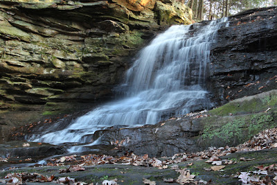
From the covered bridge we drove those four miles along route 62 to Danville then another four miles or so south, crossed the intersection with SR 36, immediately crossed a bridge over the Kokosing River then headed east on the first township road to the Honey Run Park about a mile or so east of route 62.  From that park it is a very short hike to Knox County's only waterfall (below).


As you can imagine, local folks take considerable pride in the bounty of natural scenes glorifying our area of Ohio.  It was a special blessing when it could be shared with equally special friends on a warm and sunny November day.

Saturday, November 26, 2011


A NOVEMBER BIKE RIDE--
Will December also be as kind?

A culvert under state route 83 near Holmesville, OH colorfully frames biking friends Nancy and Mark Meinzer as well as my lady Sue Brooks as we head north on the Holmes County Bike Trail from Millersburg to Fredericksburg.

Sue smiles (right) because the Village Car and Buggy Wash in the latter town serves another function as well.

Our ride that early and warm November day was a 20 mile round-trip on this dandy, multi-use trail where bicycles and Amish buggies share the right-of-way.  Buggies are confined to one side of the trail for obvious reasons.

Regardless, there often is gentle eye contact and a modest wave shared when "English" folks on their bicycles roll by our clip-clopping travel companions.

This trail now extends from Killbuck in Holmes County through Millersburg to Fredericksburg in Wayne Co., a distance of about 16 miles.  When finished it will extend from Killbuck through Glenmont to Brinkhaven where it will connect with the Mohican Valley Trail near Brinkhaven.

One day it will be a link in a continuous bike trail from Cincinnati to Cleveland.

Meanwhile it is unique as the first trail in the US to accommodate horse and buggies as well as more traditional trail users. That distinction happens here because Holmes County also is home to the largest Amish population in the country. 

The noise of highway traffic sometimes assaults the ears and makes Amish and English riders alike grateful for this travel route.

More often the trail is accompanied by the splashing of creeks which share its course through idyllic pastures and quiet woodlands.

My companions make a nicely timed passage on the trail (below, top left) as I compose the photo of a beaver dam which flooded a small tributary into an aquatic home for countless basking turtles who also were enjoying our sunny and warm fall day.

Thursday, November 24, 2011


BUGGIES AND BICYCLES--

Cultures cooperate nicely on the Holmes County Bicycle Trail where Nancy Meinzer (above) and Sue Brooks (disappearing under the sign) head out on a 20 mile jaunt recently.  Please stop by Saturday for a story on our very enjoyable, late-in-the-season bike ride.

Tuesday, November 22, 2011

BOOK REPORTS--

Born in Africa by Martin Meredith

Sub-titled "The Quest for the Origins of Human Life" the book takes a peek at the seven million years that have passed since the precursors of humankind began to evolve in Africa; always in search of the oldest human ancestor.  The whole process however was marred by the intense rivalry, personal feuds and fierce controversies of the sciences and scientists involved.  The current agreement seems to point to Homo sapiens beginning about 60,000 years ago, generally in East Africa.  More or less.


It's All About the Bike by Robert Penn

The funniest line in this book was when the author described one design of a bicycle seat as like "riding on an irritable lobster."  Penn is in the middle of a life-long love affair with bicycles and in his mid 20's pedaled around the world.  In his book he travels internationally accumulating bicycle components from top of the line manufacturers with the hope of assembling a world-class, dream bicycle.


The Rise and Fall of the Bible by Timothy Beal

The author, a professor of religion at Case Western Reserve University "...takes us back to early Christianity to ask how a box of handwritten scrolls became the Bible, and forward to see how the multibillion-dollar business that has brought us Biblezines and manga Bibles is selling down the Bible's sacred capital."  Scholars will find the book challenging.  The faithful likely will find the book unsettling.


The Statues that Walked by Terry Hunt/Carl Lipo

Sub-titled "Unraveling the Mystery of Easter Island" the authors harness the power of modern science to unravel the mysteries surrounding this extremely remote Pacific island.  Why were the island statues created and how were they moved?  Where did the native population go?  After some plodding through the abstractions of sociological theroy they arrive at horrofic and evidence-supported conclusions.

Saturday, November 19, 2011


The Opera House is the grand ole lady of Main Street in Hayesville, Ohio.  She is sandwiched quietly as the second floor neighbor of the town's post office in the commercial block east of the village stop light.

She has been there since 1886 presenting stage acts, musicals, movies, graduation ceremonies and more than a few minstrel shows.

She may not be as glamorous as she once was but, she has hosted silent movies, then the ones that actually could talk.  She has outlived eight tracks, and dial telephones and carriages that were replaced with automobiles and their fancy new running boards.

And, she still is going strong.

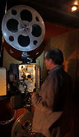
In the top photo you can see the little valves that once controlled the gas that was burned to illuminate the entryway.  Today modern spiral bulbs reside in the antique fixtures.
 
Backstage in the smaller photo (top right) Dave Roepke tells Mark and Nancy Meinzer and Sue Brooks about the colorful, original stage sets hanging in the picture.  Six of them were painted in Chicago in 1886.  Four remain.

He also points out a gentle slope to the stage.  That was designed to help audience visibility since there was not room in the building to slope the seating floor.  That technique also gave rise to the theatrical phrases "Up Stage" and "Down Stage."
  
Dave still is going strong too.  He conducts the tours and sells the tickets and mans the concession stand and runs the projector.  Popcorn sells for a buck and bottled pop is 75 cents--quite a pleasant surprise if you are accustomed to the prices of those products in the modern cinema.

Tickets for this day's movie were 3 bucks a head.

A change of film reels results in a brief intermission which lasts as long as it takes for the last person to return from the restroom.


The opera house has struggled over the years as community awareness of her true value has waxed and waned.  After sitting idle for more than 30 years a group of 600 people from Ashland and surrounding counties formed a restoration committee in preparation for the 1976 bicentennial.

They raised more than $2000 for new wiring and interior decorating.  That same year the opera house became the first Ashland County building to be named to the National Register of Historic Places.


Restoration efforts slowed until 1994 when local folks launched another series of fund-raising efforts.  They replaced air conditioning, installed restrooms and, most recently in 2009, refurbished the wooden seating.

If you glance below the seats ahead of you, you will see a circular wire object.  They are the original holders for patron's hats.


Attendance ranges from what turned out to be our private screening of the movie "Contagion" to well over 100 folks at a recent musical event.

Here sits one of life's delightful bargains just a few miles and a phone call away.  Do yourself a favor.  
__________________________
Click here for a nice recent article on the Opera House by Courtney Albon of the Ashland Times-Gazette.
For a current schedule, call Dave at 567-203-3231.

Friday, November 18, 2011


BRRRRR-GRRRRR!

Icycles cling to a stray branch after overnight temperatures in the mid-20s constructed this wintry tapestry beside the pond's spill pipe.  Splashing water is frozen into the crystal stalactites while little bubbles float merrily by.

Since my pond is part of the Mississippi River drainage basin this water soon will be passing by palm trees in the Louisiana bayous--actually, a very sensible thought this time of year.

For you photography buffs, this picture was done with a 100mm Canon, f/2.8 macro lens.  In this case it performed the role of a modest telephoto lens allowing me to enjoy a fairly close view while clinging to the creek's bank.

The camera was a Canon Rebel T3i digital, single lens reflex.  This model has a fully articulated viewing screen which allowed me the comfort of swinging the screen so its was visible as I held the camera near water level while I remained high and dry and composed the photo.

Thursday, November 17, 2011


LIVING HISTORY ON MAIN ST--
Hayesville, Ohio


Buffalo-Bill Cody signed the backstage wall of the opera house during his "one night" performance there on October 28, 1888.  The signature has been abused and cleaned over the ensuing 123 years.  (Remember, you can click on blog images to examine a larger view).

Please stop by Saturday when Fogeyisms will take you inside this marvelous trophy of local history for a peek at what we enjoyed during our recent visit.

Tuesday, November 15, 2011

MY HYPOTHESIS--
Today's Standard of Excellence is Mediocrity

My online supplier recently shipped a vest to me via UPS.

It arrived at their local terminal on a weekend and was on the little brown truck for delivery Monday.

For some reason, however, rather than delivering my package to my home, as both UPS and FedEx have done for the past 19 years, they surrendered it to the US post office in Bellville.

Once the post office got involved my package did not come into my possession until Wednesday and I had to go to the post office to get it.

This pathetic episode reminded me of another recently botched delivery by the post office when my priority mail package was sent to the wrong post office distribution joint where it languished until someone, I presume, could finally find Bellville on their Ohio map.

That one left the shipper, addressed correctly by the way, on a Monday and with the post office's version of priority handling, arrived here on a Friday.

Saturday, November 12, 2011


A VISUAL TREAT--
On our trip across Ohio

Delphos, OH, which describes itself as "America's Friendliest City", was the most visually interesting to us in our trip across Ohio's Lincoln Highway (LH).

The town is a little less than 3 miles square and contains about 6,700 souls but its history smacks you in the nose on arrival.

The Miami and Erie Canal rolled toward us on the GPS while the fabled highway morphed into 5th St., as we slowed into the downtown.

On our right was a delightful mural depicting the town of the 1950s.  A LH "control station" sign is at the west end of this building (pictured below).  If you set your odometer to zero there, your mileage will conform to the directions in the local copy of the 13 US Coast and Geodetic Survey maps that cover the highway across Ohio from east to west.

At the canal which crosses the LH straight ahead there is an historical marker that also shows the elevation changes in the canal from Toledo to the Ohio River at Cincinnati, a distance of 249 miles.

Delphos grew out of four different villages in the early 1800s, three named after the families of settlers and one after a plat of land.  From 1836 to 1842 the town began to assemble itself while the canal was being built and Delphos was officially established in 1851.

By 1879 over 100 factories were operating there, providing goods to the world's commerce because both the canal and the nation's first paved, transcontinental highway passed through its boundaries.

But, already, railroads were encroaching on the canal's lucrative business.  From 1850 to 1860 railroad track in Ohio grew from 375 to 2,946 miles and the canal was history after devastating floods in 1913.

Another mural on the side of the Delphos Herald building (above) enjoyed dramatic back lighting during our visit.  That mural actually depicted its own location.  Note the shape of the building in the photo being reproduced in the painting.

The locally preserved section of the canal is located behind the newspaper building.  The water flowing in the small photo (above) supplies water to local industries to this day.

While the town displays its history proudly it doesn't appear to be terribly busy otherwise.  Under the section of "local activities scheduled" on its web site--there is nothing listed.

As we walked across 5th St., in our photo session, holding hands as we often do, a lady in a passing SUV opened the side door of the moving vehicle and inquired how long we have been married.  "We're not," Sue responded to the obvious disappointment of our inquisitor.

My simultaneous response to the passing lady was, "That's why we still are holding hands."

I don't think she heard me.


_____________________________
http://www.cityofdelphos.com/

Editor's Note:  We conclude our series on the western half of Ohio's Lincoln Highway with this photo taken in Delphos which not only demonstrates a violation of the laws of composition, but a violation of the traffic laws as well:


Serious photographers should avoid having things like telephone poles and signs growing out of the heads of folks in their photographs.

And, drivers always should be alert to one-way traffic signs.

This photographer was guilty on both counts; neither of which was noticed until the pictures were being edited.  * Gasp *

Thursday, November 10, 2011


FIRST COUNTY LIBRARY IN THE US--
On the Lincoln Highway in Van Wert, Ohio  

In 1890, 12 women in Van Wert, OH formed the Van Wert Ladies Library Assoc., to establish a subscription library for residents in the area.  That library contained 1,400 books and became a free, city library in 1896 as a result of a city tax.

Meanwhile John S. Brumback who was born in Licking County in 1829, moved his family to Van Wert in 1862 and established a dry goods store.  Twenty years later he became the first president of a local insurance company.  In 1884 he sold his store and bought controlling interest in the Van Wert National Bank and went on to become known as a keen businessman and philanthropist.


He believed all county residents should have access to a free public library and offered his financial support to making that happen, but, he died before building plans he had ordered could be completed.

His family fulfilled his wishes and his son was responsible for the legislation passed by the Ohio Legislature approving the first tax-supported public library in the United States.

The cornerstone for the library was laid in 1899 and the building was dedicated in 1901, 12 years before the Lincoln Highway was launched.

To this day the library sits in a public park on the near west side of Van Wert on the original alignment of that famous highway.

It was added to the National Register of historic Places in 1979.
________________________
http://www.brumbacklib.com/

Tuesday, November 8, 2011

BOOK REPORTS--

2012 and the End of the World by Matthew Restall and Amara Solari

The authors, both professors at Pennsylvania State University, have more than 30 years experience studying the Mayan culture, hence are well equipped to examine the popular prediction the world will end in December 2012.  In professor jargon, here's one of their revealing comments:  "...as with the more hysterical 2012 literature, or as the butt of parody, which is what 2012 is no doubt soon destined to become."  

Regardless of who is right, I did go ahead and buy that expensive camera I've been drooling over.


Wild Bill Donovan by Douglas Waller

Donovan is described as the spy master who created the OSS (during WW II) and modern American espionage.  In its nearly 400 pages the book takes a close look this WW I hero who won the Medal of Honor, went on to achieve the rank of general in the Army then formed the organization known today as the Central Intelligence Agency.  This is a dandy read--if you are a military historian.


The Haunted History of the Ohio State Reformatory by Sherri Brake

This is another of those relatively little, 150 plus page paperbacks; this one a quite interesting read about the historical Mansfield facility.  There is lots of local history here including a chapter on a Civil War camp that preceded the reformatory--and, as is suggested, may have contributed to some of the paranormal activity described.  I found it curious the author waited until the 85th page to finally get to the "Spirits, Ghosts and Shadowy Encounters" clearly implied as the central theme in the book's title.


Flashback by Dan Simmons

This is a chilling, Orwellian-like novel which takes a peek at the near-future US where a huge percentage of the population is addicted to the drug "Flashback".  There, they blissfully enjoy the past while ignoring the country's unbelievable turmoil under the threat of an Islamic Global Caliphate.  It is a chilling tale of the Muslim march to world dominance.

Saturday, November 5, 2011


We found the above historical marker as we approached downtown Upper Sandusky from the east on the Lincoln Highway--today known as Wyandot Ave.  Note the pink area of road surface to the left.  That is some of the rarely found, original brick surface of the Lincoln Highway.  Some crumbling asphalt road surface of the old highway is visible in the lower photo alongside what is now County Highway 330, 5.3 miles west of downtown Upper Sandusky.


TRAVELING ACROSS OHIO--
On the Lincoln Highway; part 2

We launched this half of our trip across Ohio on the Lincoln Highway (LH) from downtown Mansfield and headed west on Park Ave.

The original Proclamation Route of 1913 took the LH from Mansfield to Galion, Marion, Kenton and on to Lima.  We know that today as SR 309.  Earlier it became known as US 30-South.  But, just three weeks after that route was established the route was changed and, after Galion, went to Bucyrus and on west through Upper Sandusky.

In 1920 a new road from Mansfield to Bucyrus left town via 4th Street.  It became known as US 30-N and went through Crestline.  For a short while that route branched through Leesville then rejoined route 30 on the way to Bucyrus.

Today, at the corner of Park Ave., West and Western Ave., you will see a sign directing the LH north on Western Ave.  That is where the 1920 alignment changed and coursed via 4th St., through Crestline, Bucyrus, Oceola and on to Upper Sandusky on its way west.

There were a few other routing curiosities in this segment.  An earlier version of route 30 followed what we now know as Mabee Rd., for a short while.  From my childhood recollection that could have been caused by localized, swampy areas that were easier to go around.

A similar event happens west of the new four-lane interchange where route 30 used to follow segments of Eckstein and Snodgrass Rds., for a half mile or so.

That was our route of travel avoiding, of course, the new four-lane US 30 which now extends from Mansfield to Indiana.

After the new four lane highway captures route 30 traffic west of State Route 314 it gets quiet.  Very quiet. 

We were able to stop in Crestline and ponder LH signs without the snarl of diesel powered traffic.

We did the Leesville detour and didn't even have to signal our turn to other traffic.  There wasn't any.


This entire route is dotted with LH signs like the one pictured on the viaducts just after the golf course as we approached downtown Bucyrus.

We trundled along a leisurely 16 miles from Bucyrus until we encountered the historical plaque in the lead photo above on the east side of Upper Sandusky.

As we enjoyed our solitude I was reminded we were experiencing a highway that was the first paved one across the US.  This road's history began in 1913.  The 1920 route change mentioned above happened just 20 years before I was born.

Thirty six gentle miles later we had crossed I-75 and were in the village of Beaverdam.  Here the coast-to-coast LH intersected the north/south, transcontinental road known as the Dixie Highway which traveled from Michigan's Upper Peninsula to Key West.
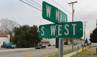
Just imagine, those two major, US highways crisscrossed on the tiny street in the tiny town pictured behind the road sign of Main and West Streets. 

There was not a lot of traffic fuss in those days when there were more horse hitching posts than parking meters on the town's main street.

Ten miles west of Beaver Dam we crossed Pike Run creek and paused briefly to note the site that snarled Admiral Byrd's "Snow Cruiser." which was on its way to an Antarctic expedition in 1939.  News accounts of the day said the cruiser hit a bridge and stumbled into the creek causing several days of delay until it could be hoisted out and continue its journey.

Just a few miles west of the accident site our notes indicated we would encounter the "Beach ridge" of the Maumee Glacial Lake which would parallel the LH route nearly 50 miles into Indiana.

The Wisconsin Glacier of the ice age of 14,000 years ago stopped in this area and, while melting, dumped its debris into things geologists call moraines; ridges that later became the routes of trails then highways in modern history.

In the incredibly flat topography of western Ohio this "ridge" was barely discernible.

As we approached Delphos we passed the old junction point of US 30-N and US 30-S where US 30 became whole again.

Thirteen miles northwest of Delphos we enjoyed a visit to Balyeat's Coffee Shop in Van Wert (left) where a patron caused Sue to chuckle as he hustled to avoid our photography.  He was a retired fellow, working part time for the local florist and heading to Balyeat's for lunch as folks have done here since the restaurant opened in 1924.

About nine miles west of Van Wert the old road disappears under the new four-lane US 30 which roars on another 6 miles to the Indiana line.

Here, the modern highway has obliterated one of the original "Seedling Miles".  These miles scattered along the LH route through Ohio were then very modern concrete slabs meant to inspire further highway improvement after locals experienced the contrast between driving on the original then newly paved portions.

Also in the area from Van Wert to Indiana it looks like a continuous orchard of electricity-producing wind turbines.  Strangely restricted to the north side of US 30, these huge white pillars, each topped with an enormous, three-bladed propeller, turn slowly at the prodding of whatever wind Mother Nature happens to be providing.

Below, a melancholy trucker finishes yet another fast-food lunch at a truck stop near Beaverdam.  He originated in Milwaukee, picked up a load of scrap in Pennsylvania and was on his way to a delivery in Green Bay, WI. 

It was easy to see through his eyes and appreciate modern highways making possible in hours what it took months to do with motor vehicles just 90 years or so ago.

Still, I am not convinced all "progress" goes forward.

Friday, November 4, 2011


THE LINCOLN HIGHWAY REVISITED--

Tomorrow we share the story of our travel across the western half of Ohio on the Lincoln Highway from Mansfield to the Indiana state line.

In the above photo the Lincoln Highway sign perches on a pillar symbolic of the original location of that historic highway as it now crosses I-75 near Beaverdam.

Stories to follow Saturday's will include visits to Delphos, and a very historic library in Van Wert.  Yet to be produced is the story on a visit we hope to enjoy at the J & M Trading Post in Leesville.  On the day of our Lincoln Highway trip the trading post was closed but, the sign in the window invited us to call if they were closed when we passed by.  We hope to do that.

Plus, we also have visited the Hayesville Opera House, first mentioned in our earlier story of traveling the Lincoln Highway across the eastern half of Ohio.  The opera house story will follow on November 19th.

Please stay tuned.

Wednesday, November 2, 2011


This judicial candidate's presentation was about as bland as the above photo of him addressing a recent Monday lunch of the local GOP in Mansfield.

OLD TIMES REVISITED--

It has been about 25 years since I last attended a weekly, Republican lunch in downtown Mansfield.

This close to the election the lunches give current candidates a forum to present themselves and their campaign thoughts to a highly supportive and partisan crowd.

My near quarter century of absences began when I left the commissioner's office in the county courthouse in 1987 and drifted into the political obscurity of serving as treasurer of the Clear Fork Valley Local School District.

One person I was delighted to see at this lunch spanned those years of my absence; Ken Humbert, formerly of the Shiloh area and yet now a GOP precinct committeeman from his Mansfield home neighborhood.

It was marvelous to introduce Sue to Ken while we meandered briefly through that shared history of political involvement from the late 1970s, a few years before Ronald Regan was elected president.

County engineer Tom Beck was there as was Sarah Davis, country recorder, and Sue and I both signed their petitions for reelection, the start of next year's electoral cycle.  It was nice to inquire about Sarah's husband Aaron, a long retired Mansfield Realtor who is managing his early 90s these days.

Adrianna Miranda joined us at our table for lunch.  She was an exotic young lady from Argentina when I first knew her back then.  Now she is the very gracious GOP nominee for 6th ward council in Mansfield and chuckled knowingly when I inquired about the ratio of Democrats versus Republicans in her ward. 
My favorite candidate in attendance was Marianne Gasiecki, running for the Ontario Board of Education, as well as serving with distinction as the founder of the Mansfield Tea Party Patriots.

Frankly I am more pleased about her Tea Party work than I am with the Republican Party.

But, I also regard it a privilege to know Barbara Walter who is an enthusiastic co-worker with Marianne in the Tea Party movement while she also serves as chairwoman of the county GOP.  Go Ladies!

Barbara and I recently discussed Ryan Hoovler, candidate for Clerk of Mansfield Municipal Court.  She was delighted to tell me his presentation to this very group a few weeks earlier was rewarded with a standing ovation.  "I was so proud I wanted to adopt him," she enthused.

That's Jerry Thompson, candidate for judge of Mansfield Municipal Court in the above photo.  He was successful when I confronted him earlier with my litmus test for all candidates but he needs to spend more time being sincere with his audience than looking at his carefully constructed speech notes.

Tim Theaker, GOP candidate for Mayor of Mansfield was there.  He sat across the room and, well, smirked.  I wondered why he never bothered to offer his candidacy to the newcomers in the room.

Maybe he has an ample supply of committed votes already.

Maybe not.