Saturday, July 31, 2010


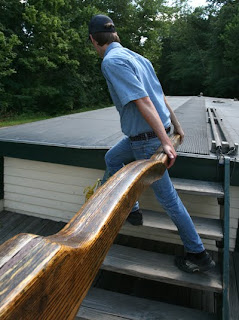
The very top of the multi-storied furnace structure (called the charging house) is shown in the top photo as seen from inside the nearby storage shed. Raw materials were moved from the storage shed into the charging house where the process of making molten iron began.

The raw material would become molten and flow down through the furnace into the casting shed (the front end of the structure in the lower photo) where it would be cast in the sand molds into pig iron.  Many authentic supplies of the period are shown on display in the interior of the reconstructed company store (small photo below).


THE BUCKEYE FURNACE—
of Jackson County, OH

Today’s story takes a peek at one of only three restored, charcoal furnace locations in the US; this one in the hills of southern Ohio.

These “furnaces” produced pig-iron and were the industrial forerunners of today’s steel industry.

This furnace and 68 other such sites comprised the “Hanging Rock” iron region that extended through southeastern Ohio and northern Kentucky. Iron making began here in the 1830s and ultimately provided Union forces with a vital material for the Civil War effort.

The iron used in the Union ship “Monitor” came from a furnace in nearby Oak Hill, Ohio.

These furnaces were located here because of the readily available raw material; large forests to produce the charcoal fuel to fire the furnaces, the iron ore itself, and limestone which made the flux that purified the molten iron.

The phrase “pig iron” comes from the shape of the molds used to make the iron ingots. The molten iron was poured into a branching structure of sand molds with a configuration similar to the appearance of a litter of suckling piglets.

Usually a small community was born at the location of these furnaces. They often had populations of 300 to 400 folks and were self sufficient.

The furnace company owned everything in the pig iron producing community including the housing and the company store (right). Workers rented or bought everything from the company usually with inflated prices. Purchases often were made with “scrip” or company money.

Often a worker would find his “scrip” was insufficient to pay his bills to the firm. Years later this was lamented in a song made famous by Tennessee Ernie Ford, “I owe my soul to the company store.”

“This industry prospered during and shortly after the Civil War,” according to the Ohio Historical Society. “But, as America began expanding its industrial strength it became plain a different method of making iron had to be found.”

"As new technology emerged the demand for charcoal-produced iron waned. The result was the swift demise of this once vibrant industry."


Mark Meinzer does some photo work in the interior of the casting shed above while Don Karger does likewise in the lower view which is looking through the casting shed toward the lower front of the furnace building.

The large round object in the right of the lower photo is the slag wheel. A chain extended from this wheel to the molten iron that was being poured. A man would walk up the pegs shown extending horizontally from the wheel, causing it to turn, pulling the chain and the slag impurities from the iron and away from the casting where it would cool and be discarded.


Thursday, July 29, 2010


SHADES OF DELIVERANCE--

We bounced and wiggled and crunched our way down the snake-bit roads of southern Ohio looking for the Buckeye Furnace; Jackson County’s major, historical attraction.

Several times I saw our square-dance companions in the following car disappear in the clouds of dust we were creating.

It was one of those rolling country roads with no evidence of utility lines. The occasional, modest, hill-side home often looked like it didn’t expect to have electric service; or garbage service either.

I began to be concerned about that road closed sign we had seen several miles back; hoping that obstruction to our progress did not occur before our destination arrived.

Wrong.

We nuzzled up to a pile of concrete debris which convincingly stopped all vehicle progress (above photo) right before an ageless covered bridge. Eight of us wandered around what was turning into a dilemma—which by definition, of course, is a choice between unsuitable alternatives.

Our destination was directly on the other side of the bridge and our choices were to leave our cars parked where they were and walk to the historic site visible beyond, or, retrace our arrival route until we could be GPS’ed around what looked to be a miles-long detour.

Our decision was made when we discovered the sound of roosters behind a nearby, ah, dwelling, was coming from individual birds secured to individual houses--a chicken domicile that looked suspiciously like a cock-fighters boot camp.

That prompted Nancy Meinzer to share; she was having visions of the movie Deliverance and, by her prompt return to the vehicle nudged us to decide this circumstance really was not the best place to leave two SUVs unattended.

We bit the bullet, so to speak, and meandered our way over a course of much more cooperative roads to our destination. Please stop by Saturday for the story of this fascinating slice of Ohio history.


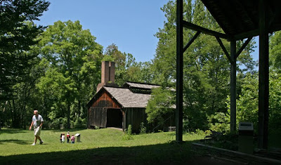
In this post-detour photo Russ and Jane Matz, Roberta Karger, Sue Brooks and Nancy Meinzer head for a restored country store that once served as the commercial center of this mid-1800s industrial site. Eight of us were in Jackson County for a weekend of square dancing and enjoyed this outing before Saturday night’s dance.

Tuesday, July 27, 2010


My pal Max died Sunday morning.

I know he is gone. But, memories of his 14 years in my life are treasures seared into my brain and my heart forever.

I’ll never forget:

...seeing him watching through the deck door for me to come home and wondering how long his vigilance right there had been.

...hearing him thump his empty dish on the floor; announcing his food supply needed my attention. Right now please.

...feeling him arrive by my side when storms were approaching; just being there as my protector, of course.

...watching him turn around on one of our trails and gently scolding me for my tardy gait on one of the bazillion hikes we shared all those years.

... scratching his lazy ear. One stood up. One didn’t and it amplified his quirky smile as he went through life as if being my pal was all that mattered to him.

As I was writing this I took my bowl to the kitchen and began to set it on the floor so he could enjoy his wee bit of a treat—then tears blurred my eyes when I was stabbed with the pain of reality.

My son Brian and his wife Kate and their grown children Brit and Dane and my lady Sue all were here in the afternoon and we buried my pal right there beside one of our favorite trails in the woods.

Good by my friend.

Good by.

Saturday, July 24, 2010


THE CANAL BOAT MONTICELLO III

The team of horses crunched its way along the 10 foot wide tow-path unbothered by the burden of the canal boat they were propelling at the lazy pace of a warm summer day.

I was engaged, as a passenger might have been back then, in combat with pesky mosquitoes as my imagination drifted to the middle 1800’s when the canal-based economy was at its height in our young state.

Leaders of the period believed, correctly as it turned out, the construction of a series of canals around Ohio would give a big boost to the new state’s economy. Remember, our state wasn’t formed until 1803.

In 1822 a canal commission was established by the state legislature and it hired a surveyor to identify the best canal routes to connect Lake Erie with the Ohio River.

The first route identified ran along the Maumee and Miami Rivers in western Ohio. The second dropped south through the middle of the state and used the Sandusky and Scioto Rivers. The eastern-most route included the Cuyahoga and Muskingum Rivers.

The commission finally settled on the route that originated on the shore of Lake Erie in present day Cleveland, and followed the Cuyahoga, Muskingum, Licking and Scioto River Valleys to present day Portsmouth on the Ohio River.

The first shovel of dirt was turned on the massive project July 4, 1825 at Licking Summit south of Newark. Swamps in the area were drained to form what is now known as Buckeye Lake to create a reservoir to supply water to that section of the canal.

All work was done by manual labor with picks, shovels, wheelbarrows and carts.  Laborers were paid 30 cents per day and worked daylight to dark.

The first canal boat navigated past that site in 1831 on a 300-plus mile waterway that cost $12,000 per mile to finish. That was the Ohio and Erie Canal.

Many of Ohio’s towns, including Akron, began as communities for the canal workers. Summit County, surrounding present day Akron, got its name from being the highest elevation on that canal.

Shipping costs declined dramatically when the canals were completed—from $125 per ton to $25 per ton of goods. The cost for a passenger to ride the canal from Cleveland to Portsmouth was $1.70 and took 80 hours.

Ohio’s canal system went on to include a second canal from Toledo to Cincinnati and many other segments. There is a short stretch of canal in the Muskingum Valley near Zanesville still in operation today.

The canals overall remained in operation until the late 1800s slowly losing out to the new railroads. Ultimately, the canals were abandoned after a huge flood in 1913 caused more damage to the system than was feasible to repair.

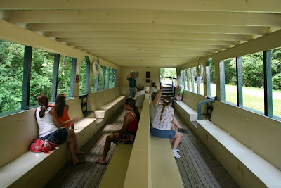
This canal boat (top and bottom) operates along a section of the old Ohio Erie Canal in Coshocton, OH and treats visitors to a 45 minute ride.  The tiller operator (right above) steers the vessel midway between the banks while the captain entertains passengers with the history of Ohio's canals from the 1800s.


Thursday, July 22, 2010


A team of horses walks the towpath along the old Ohio and Erie Canal near Coshocton, OH and treats passengers to an extraordinarily tranquil ride in this form of 19th century, public transportation.

Please stop by Saturday and ride along as Fogeyisms takes a peek at this slower-paced slice of Ohio's history and commerce.

Tuesday, July 20, 2010

COMMENTERRY--

My recent lunch purchase at the local Dairy Belle came to $5.07. I handed the young lady clerk a 10 dollar bill and, after momentarily fumbling in my pocket, a quarter.

She stared at me with a blank expression.

I inquired, “Is there something wrong miss?”

She stammered, “I’m terrible at math.”

Evidently she had wrung my amount tendered at $10 while I was fumbling for my change, then, simply could not deal with my quarter.

She stood there waiting while the other young lady clerk who was summoned to be of assistance was busy with another customer.

I said, “Miss, if I owe you seven cents and give you a quarter you owe me 18 cents in change. Do you agree?

She did, hesitantly.

I said reassuringly, “Good. Now I only owe you 5 dollars and I gave you a ten. You owe me five dollars change. Does that sound correct to you?

She actually pondered that for a moment.  Then I invited her to consult her co-worker when she was available; pointing out I would be eating in the booth right over there in case they reached a different conclusion on my transaction.

Good grief.

Here was a high school student-age person without the simplest math skills of adding and subtracting.

I was embarrassed for her so I did not ask where she went to school. But, if it has been in the local public school system, some serious questions need to be asked someone.

Sunday, July 18, 2010


GOTTA MOW THESE WEEDS--
Maybe tomorrow.
Maybe not.

Saturday, July 17, 2010


Square dancing and bicycling friend Linda Warren (top right) was part of our group of 9 enthusiasts who spent a recent Sunday rolling across Kelley’s Island in Lake Erie. That’s lady friend Sue Brooks (right) who staved-off her ever-present threat of seasickness in the relative comfort of the passenger cabin of our ferry.


AN ENCHANTING DAY—

Even the weather was fairly kind to us that day. While temperatures and humidity were challenging, the forecast storms didn’t pester us seriously until we headed for our evening meal before catching our ferry back to the mainland.

Then the sky snapped and sizzled with a deluge like Niagara while we munched to the beat of island music.

Add us up and we likely were pushing 600 collective years. But, age didn’t matter that day.

Fittingly, our first stop out there was Inscription Rock; a stone tablet of prehistoric Indian pictographs thought to date from between AD 1200 and 1600. Put our ages end-to-end and we could almost remember that span of time.

Our bike ride was a click over 11 miles—a fairly thorough, rolling romp on an island that is only 4 miles square.

And, our usually modest velocity allowed lots of time to savor the island delights as they slid into view, one-by-one.

I rode a wee bit and enjoyed the company of a butterfly whose journey just happened to be in my direction.

The on-shore breeze had that musty-fishy hint of scent that delighted the nautical memories.

We enjoyed Glacial Grooves, another geologic snap-shot from antiquity. We briefly pondered the surf-splashed beach slightly visible through the trees, but, rolled quietly by that noisy scene.

The bowels of the island are visible lots of places where quarries, past and present, have been mined to satiate the world’s limestone markets.

We stopped by the island winery and behaved ourselves—more or less.

With an awareness our magical day was ending, dinner conversation turned to our next outing. I suggested we ramble east to that spot where Pennsylvania, West Virginia and Maryland are nearly co-joined and spend a couple of days hiking three state’s worth of the Appalachian Trail.

My enthusiastic companions quickly began to compare calendars and we tentatively settled on an early fall weekend.

Stay tuned.

Mark Meinzer does an image of Glacial Grooves located on the north end of Kelley’s Island. Deep, rounded cuts were carved in the island’s limestone during a previous ice age when glaciers ground their way through the area. This sample—which is 430 feet long, 35’ wide and 15’ deep--is the largest in North America.

Thursday, July 15, 2010


ROLLING AROUND KELLY’S ISLAND ALL DAY--

Pictured variously above and in our feature story Saturday are eight of my square-dancing and bicycling companions who recently spent a day on the headlined island. They are: Mark and Nancy Meinzer, Don and Roberta Karger, Dick and Rosa Hatfield, Sue Brooks and Linda Warren.

In the photo above from left are Nancy, Mark, Sue, Don and someone’s daughter taking a peek at Inscription Rock.

The entire crew stopped for a visit at Horseshoe Lake (lower photo). This area was quarried from 1933 to 1940 and once was the bottom of the Devonian Sea from the Earth’s far distant, past.

We hope you will stop by and enjoy our adventure.


Tuesday, July 13, 2010

SIMPLE PLEASURE—


It was an impromptu dinner out that Friday night that morphed into one of life’s spontaneous and warmly enjoyable events.

After dining, we left the Oak Park Restaurant and enjoyed a couple of random, back-road turns when I offered to show our companions a near-by eagle’s nest; one of at least four local nest sites that had been active earlier in the Spring.

From there we rolled down Harlan Rd., to SR 603 and a visit to the secluded Copus Monument.

It is an off-the-beaten-path memorial to a family and friends slaughtered by Indians there in 1812.

We decided to continue wandering the back roads under cumulus cloud remnants arranging themselves in a spectacular sunset framework while enjoying the first few of nearly countless whitetail deer that shared the quiet pace of our summer evening.

Sue and I were with our friends Don and Roberta Karger and were grateful for that fact alone.

The highlight of our countless deer sightings was the spotted fawn peering at us through a wire fence with a mournful expression while the township road separated it from momma deer.

Their reunion likely happened shortly thereafter as we slid quietly down their road and passed through Pinhook, OH. That’s one of those small places where the entry and exit signs for the town are on the same post.

I silently remembered renowned artist George M. Biddle had a hilltop home there where he died in 1959.

Somewhere along our way down there in the hilly woods of Monroe Township we obeyed the right-of-way of a squadron of young turkeys. They clucked and we smiled and all was well.

We trundled through the boat launch area of Pleasant Hill Park and enjoyed families; themselves enjoying the timeless pursuits of boating and fishing on a warm, summer evening while sparks blossomed from nearby campfires.

We eased up Bromfield Rd., and pondered almost visible apparitions from the story of Ceely Rose and the ghastly events of the late 1800s in that house right over there on Louie's Malabar Farm.

On a dead end of Tucker Rd. with daylight failing, our skin tingled again with legends of the paranormal as we visited the desecrated cemetery of Mary Jane’s grave then wandered toward home up Hastings-Newville Rd.—the latter name for a town long abandoned and submerged under the lake now known as Pleasant Hill.

As we bade good night Venus sparkled in the Western sky as if it was a celestial exclamation point to our collective gratitude for the simple pleasures just shared.

Saturday, July 10, 2010


Finished Jones’ Chips move along the elevated line high above the production floor while (lower right) a potato is pushed manually through a spare slicer head that cuts the potato chip into its very distinctive shape.


Marcelled
JONES’ CHIPS

Our story on Mansfield’s very-own, Jones' Potato Chip Company actually has its origins in my youthful memory of their delicious smell as they cooked in a nearby neighborhood on Bowman St., more than 60 years ago.

Later, a larcenous raccoon with good taste moved the story along when it stole our bag of Jones Chips on a camping trip--and I even more recently offered to share that photo with the company.

That led to my acquaintance with President Bob Jones and a tour of their modern facility just a mile or so north of the origin of those delightful smells, still firm in the memory from my youth.

Bob’s father Frederick launched his business by hand cooking his sliced potatoes in kettles in that original building about the size of a three car garage. While that cooking process became fully automated by the 1970s, it is interesting to note kettle-cooking has returned to the industry as a trendy variation of his original production technique.

Jones enjoyed rapid growth and four expansions to his first shop then expanded once again into the old A & P grocery store just a bit south of his original location on Bowman St., and adjacent to the old location of the Gorman Rupp Pump Co.

The company operated there from 1978 to 1988 when they grew once again into a 30,000 square foot facility on National Parkway. They have 50,000 square feet of space in their current building.

Bob’s older brother Steve ran the company for 30 years after their father’s retirement in 1966. Bob has been at the helm of the family firm since May of 1996.

Today they consume more than eight million pounds of potatoes annually in the production of 2 million pounds of their tasty products.  Most of the weight loss is in the form of water in the raw potatoes.

Potatoes are loaded into the front end of their production facility where they are washed, then skinned in a large, abrasive drum. A sharp-eyed lady then culls damaged potatoes before they enter the slicing apparatus.

From there the chips are blown dry, twice, then plopped into a huge fryer for cooking at a very precisely controlled temperature and length of time. Careful selections of two cooking oils and maintenance of fresh oil quality are also principal ingredients in their product’s distinctly, pleasurable taste.

The cooked chips are de-oiled and dried and shaken and inspected and seasoned and inspected some more as they accelerate their way to a highly automated packaging line before being boxed and shipped to the retailer.
Bob points to designs in their new facility that will allow the future addition of a second production line. When that is added with more production hours, the stage is set for their next and anticipated spurt of growth.

As I walked to my vehicle I could not help but wonder what would have happened to that huge and now-vacant automobile plant out on Fourth St., if the Jones boys had applied their work and product quality ethics to building cars.


Company president Bob Jones (left) tracks the final stage of packaging in the highly automated end of the production line as a worker prepares to move the latest filled, box to the shipping department.

Thursday, July 8, 2010


“Family Owned
Since...”

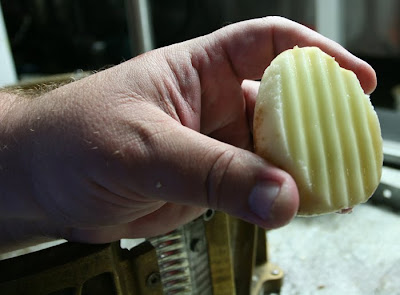
This potato (above) was manually pushed through the slicer that gives Jones Potato Chips their descriptive name. The hand in the photo belongs to Bob Jones, president of the Mansfield-based company which traces its birth to Jones’ father Robert in1945—actually several years before that, but World War II intervened.

Naturally, the slicer is automated. It is a circular drum with knives of the marcelled shape that cut the distinctive form of the tasty chips at the front end of the modern production line in their new facility on Bowman St., just north of US Route 30.

Please stop by Saturday and Fogeyisms will accompany President Jones on a VIP tour of his shop which opened in January of this year.

Wednesday, July 7, 2010

COMMENTERRY--

Yesterday’s headlines barked:

“NASA’s ‘foremost’ mission is now to improve relations with Muslim world...”

Next we’ll be hearing O-bozo asking Slick Willie’s squeeze to be in charge of US rocket science.

Tuesday, July 6, 2010


HAPPY BIRTHDAY AMERICA
Happy Birthday Myron
Happy Retirement Sue


The 4th of July holiday weekend started with lady friend Sue Brooks’ retirement. Nancy Meinzer and husband Mark (above left) with a group of 11 square dancing friends helped Sue celebrate her first hours of retirement Friday evening. The wildflower Canada Lily joined Sue’s celebration by blooming on the shore of my pond.


Saturday seared the soul with slices of Americana everywhere.

...a breakfast with bicycling friend Ken Johnson (right) and his bride JoAnn. ...a bike ride in the annual Bellville parade. ...the Freedom Festival and car show at the Mansfield airport. ...my pilot friend Myron Collier’s 80th birthday celebration. ...another bike ride, this one with the Mansfield Tea Party in the Ontario parade. ...concluding with a sunset visit to Ashland’s Balloonfest where towering balloon’s glowed with their gas light as the sun set on our nation’s birthday party.

Pshew!

At the Don and Roberta Karger home Friday evening it was a sit-down dinner for Sue then the warm magic of fellowship around the fireside with intensely caring friends.

Saturday was stuffed with events that would have made Normal Rockwell proud.

My little village of Bellville is small-town America on this anniversary of our nation’s birth.

Our friends Dick and Rose Hatfield had their sparkling 57 Chevy front and center at the Mansfield airport celebration where lady friend Sue and grand daughter Mackenna are dwarfed (right) by the engine of an air national guard C-130 aircraft.

My pilot friend Myron Collier flew for years for The Empire Steel Company, under its various names and retired commanding one of their fleet of corporate jets. He also was the FAA examiner who sweated me through many of my flying licenses and ratings.

That’s Myron on the right in a backyard scene typical of this land that stretches from sea to sea.

His wife Pat, herself a veteran pilot, beamed as family and friends toasted Myron’s 80th birthday while he, all the while, shook his head in amused denial of his longevity.

My celebration grew more somber in Ontario’s parade where I bicycled the route with the Mansfield Tea Party and pondered the work ahead in getting our nation back on track from the train-wreck of current Washington, DC politicians.

Our weekend concluded with a picnic with dancing friends Russ and Jane Matz in the parking-lot of their Ashland real estate and appraisal business.

I sat there and watched the fireworks crowd assemble itself along a very busy Claremont Ave., where we had ring-side seats for the evening’s colorful and noisy spectacle.

I enjoyed the sensation of spinal tingles as our country’s birthday celebration ran its delightful course.

But, for the first time in my life I really wondered what form of US of A we were now fermenting for future generations.


Fireworks dazzled the senses as Ashland’s 4th of July party concluded Saturday night; this image being the product of some old-fashioned photography effort and a bit of digital magic with Photoshop software. I beg your indulgence.

Saturday, July 3, 2010


A pedesterian does a double take when he notices lever harp music drifting from between restored buildings in Roscoe Village, Coshocton, OH (above) while Makenna, Sue and Sandy enjoy a mural and artifacts of this canal town restoration in its modern visitor's center.


ROSCOE VILLAGE--

It was easy to walk down Whitewoman St., in Roscoe Village that day and visualize an era from long ago.

Early in the 19th century laborers were digging a canal right over there, with shovels, and earning 30 cents a day for their work. A little whiskey now and then helped stave off illness common to the frontier of that time.

Long before airplanes and vehicles; even long before roads as we know them today, canals and boats were the best opportunity to move merchandise through the wilderness being carved into our new nation.

The canals were man-made rivers connecting the natural watercourses, long used by the Native Americans.

Those men with their picks and shovels dug trenches that averaged four feet deep and 40 feet in width; large enough to float canal boats when the trenches were filled with water. The canal through this village stretched from Portsmouth to Cleveland, a distance of more than 300 miles.

The canals were even more reliable than the rivers. Water level could be maintained with a system of aqueducts and storage basins.

Large chambers were built in the canals with doors on each end so water level in the chamber could be controlled, thus allowing boats to climb and descend the changing elevations of the land. These were called locks.

Towns like Roscoe Village grew along the canal routes and supplied the needs of the laborers as well as the growing, local population.

Candles pushed nighttime darkness back into the woods in those days. Refrigeration was provided only by cool, spring water.

The canal boats hauled merchandise from the area to markets, sometimes as far downstream as New Orleans. After the merchandise was sold, so were the boats. There was no practical way for them to return upriver.

The boat crews? They often walked home; as much as 1,000 miles, we learned from the boat captain giving rides on a restored portion of the canal.

Lady friend Sue’s grand daughter Makenna dipped her own candles in a visitor’s center demonstration that day. I wondered how she equated that with her fairly short, but technologically drenched life.

I paused along Whitewoman St., to be soothed by the lever-harp musical arrangements of Paul and Brenda Neal of Coshocton. Their melodies were, indeed, hypnotic and dynamic and bold and soothing; just like the program said.

Our civilization lost more than canals when that era of slower motion passed.
_____________________________
The entire village and some of its shops can be visited free.  Most others are part of a walking tour; tickets for which cost $9.95 each.  All proceeds go for maintenance and continued restoration.

http://www.roscoevillage.com/

Thursday, July 1, 2010


Roscoe Village is a restored canal town in Coshocton, OH and the subject of our blog story Saturday.  I chuckled when I noticed this lady; thinking she might have been a bit happier if she had purchased an ice cream cone rather than her jug of carbonated pop.  Pleast stop by while we savor some ambiance from a era of long ago.