
ALTOONA POTPOURRI—
Surprisingly similar in size to Mansfield, Altoona rests in an Allegheny Mountain valley 1,206 feet above sea level midway between Pittsburg and Harrisburg, PA—the state capital. In the above photo taken from the top of Wopsy Mountain, the city is dwarfed by Brush Mountain to the east.
These mountains rise about 750 feet above the valley floor while Cresson Mountain just to the west has a peak elevation near 2,500 feet above sea level. These mountains were a huge barrier to transportation westward in the early 1800s.
Consequently a series of inclined planes were used to haul canal boats over the mountains between Hollidaysburg (near Altoona) and Johnstown (of flood fame) where they rejoined the canal westward to Pittsburg.
In the mid 1800s railroads were replacing the canals and the Horseshoe Curve—an engineering marvel of its time—was constructed to help the heavy trains climb the mountain near Altoona at a reasonable grade.
By 1858 travel time between Philadelphia and Pittsburg had been reduced to 15 hours as opposed to the three days required by canal.
The Funicular cable car system at today’s Horseshoe Curve visitor center is pictured in the top two photos on the right. The top photo shows the car and elevated track used to transport visitors up to the railroad track grade level. The lower photo is the opposite view and shows the companion cable car ascending the hill while its partner descends in unison toward the visitor center.
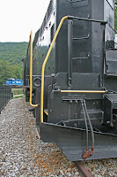
The third photo shows a diesel engine on static display at the curve viewing elevation while the blue engine in the background follows its companion back down the mountain toward Altoona’s railroad yard.
The blue engines had just an hour or so ago assisted with the chore of pulling a heavy train up the mountain and would soon be used to repeat that process with another westbound train. The angle of the grade is visible if you carefully view the degree of the blue engine’s tilt.
Another curious sight in this area is of people collecting drinking water from free flowing mountain springs. Sometimes they simply flow through a pipe extending across a moss covered concrete structure along a mountain road.
In the photo published Thursday Cousin Bob Wolf demonstrates the collection process at a huge spring in the town of Roaring Spring, PA. Visible behind him is but a small portion of the 8 million gallon-per-day flow of the spring; much of which has been diverted through a system of pipes for local use and the commercial bottling of water.
Surprisingly similar in size to Mansfield, Altoona rests in an Allegheny Mountain valley 1,206 feet above sea level midway between Pittsburg and Harrisburg, PA—the state capital. In the above photo taken from the top of Wopsy Mountain, the city is dwarfed by Brush Mountain to the east.

These mountains rise about 750 feet above the valley floor while Cresson Mountain just to the west has a peak elevation near 2,500 feet above sea level. These mountains were a huge barrier to transportation westward in the early 1800s.
Consequently a series of inclined planes were used to haul canal boats over the mountains between Hollidaysburg (near Altoona) and Johnstown (of flood fame) where they rejoined the canal westward to Pittsburg.
In the mid 1800s railroads were replacing the canals and the Horseshoe Curve—an engineering marvel of its time—was constructed to help the heavy
 trains climb the mountain near Altoona at a reasonable grade.
By 1858 travel time between Philadelphia and Pittsburg had been reduced to 15 hours as opposed to the three days required by canal.
The Funicular cable car system at today’s Horseshoe Curve visitor center is pictured in the top two photos on the right. The top photo shows the car and elevated track used to transport visitors up to the railroad track grade level. The lower photo is the opposite view and shows the companion cable car ascending the hill while its partner descends in unison toward the visitor center.
The third photo shows a diesel engine on static display at the curve viewing elevation while the blue engine in the background follows its companion back down the mountain toward Altoona’s railroad yard.
The blue engines had just an hour or so ago assisted with the chore of pulling a heavy train up the mountain and would soon be used to repeat that process with another westbound train. The angle of the grade is visible if you carefully view the degree of the blue engine’s tilt.
Another curious sight in this area is of people collecting drinking water from free flowing mountain springs. Sometimes they simply flow through a pipe extending across a moss covered concrete structure along a mountain road.

In the photo published Thursday Cousin Bob Wolf demonstrates the collection process at a huge spring in the town of Roaring Spring, PA. Visible behind him is but a small portion of the 8 million gallon-per-day flow of the spring; much of which has been diverted through a system of pipes for local use and the commercial bottling of water.
Geologists believe a subterranean lake is the source of this water flow, the roar of which was said to be audible for miles around before most was diverted—thus giving the city (known as a borough) its appropriate name.

No comments:
Post a Comment